climate classification notes
- WHAT IS CLIMATE??
- is more than "the average state of the atmosphere" because a complete climate description should also include variations and extremes to accurately portray the total character of an area.
- The most important elements in climate descriptions are temperature and precipitation inasmuch as they have the greatest influence on people and their activities and also have as important impact on the distribution of vegetation and the development of soils.
- Peerhaps the first attempt at climate classification was made by the ancient Greeks, who divided each hemisphere into three zone: torrid, temperature, and frigid
- Since the beginning of the 20th century many climate classification system have been formed
- The classification of climates is the product of human ingenuity and its value is determined
- For decades, a climate classification devised by Wladimir Köppen (1846–1940) has been the best-known and most used tool for presenting the world pattern of climates.
- The Köppen classification uses easily obtained data: mean monthly and annual values of temperature and precipitation.
- Furthermore, the criteria are unambiguous, simple to apply, and divide the world into climate regions in a realistic way.
- Köppen believed that the distribution of natural vegetation was the best expression of an overall climate.
- Consequently, the boundaries he chose were largely based on the limits of certain plant associations.
- Köppen recognized five principal climate groups, each designated with a capital letter:
- A (humid, tropical)
- B (dry)
- C (humid middle-latitude, mild winters)
- D (humid middle-latitude, severe winters)
- E (polar)
- Four groups (A, C, D, E) are defined by temperature.
- The fifth, the B group, has precipitation as its primary criterion.
- Order exists in the distribution of climate elements and the pattern of climates is not by chance
- The worlds climate pattern reflects a regular and dependable operation of the major climate controls
- The major controls of climate are:
- (1) latitude (variations in the receipt of solar energy and temperature differences are largely a function of latitude),
- (2) land/water influence (marine climates are generally mild, while continental climates are typically much more extreme),
- (3) geographic position and prevailing winds (the moderating effect of water is more pronounced along the windward side of a continent),
- (4) mountains and highlands (mountain barriers prevent maritime air masses from reaching far inland, trigger orographic rainfall, and where they are extensive, create their own climatic regions),
- (5) ocean currents (poleward-moving currents cause air temperatures to be warmer than would be expected), and
- (6) pressure and wind systems (the world distribution of precipitation is closely related to the distribution of Earth's major pressure and wind systems).
- Situated along the equator, the wet tropics (Af, Am) constant high temperatures and year-round rainfall combine to produce the most luxuriant vegetation in climatic realm—the tropical rain forest.
- Temperatures in these regions usually average 25°C (77°F) or more each month and the daily temperature variations characteristically greatly exceed seasonal differences.
- Precipitation in Af and Am climates is normally from 175 to 250 centimeters (68 to 98 inches) per year and is more variable than temperature, both seasonally and from place to place.
- Thermally induced convection coupled with convergence along the intertropical convergence zone (ITCZ) leads to widespread ascent of the warm, humid, unstable air and ideal conditions for precipitation.
- Dry regions of the world cover about 30 percent of Earth's land area.
- Other than their meager yearly rainfall, the most characteristic feature of dry climates is that precipitation is very unreliable.
- Climatologists define a “dry climate” as one in which the yearly precipitation is less than the potential water loss by evaporation.
- To define the boundary between dry and humid climates, the Köppen classification uses formulas that involve three variables:
(1) average annual precipitation,
(2) average annual temperature, and
(3) seasonal distribution of precipitation
- Humid middle-latitude climates with mild winters (C climates) occur where the average temperature of the coldest month is less than 18°C (64°F) but above -3°C (27°F).
- Several C climate subgroups exist.
- Humid continental climates with severe winters (D climates) experience severe winters.
- The average temperature of the coldest month is -3°C (27°F) or below and the average temperature of the warmest month exceeds 10°C (50°F).
- The greatest annual temperature ranges on Earth occur here.
- Polar climates (ET, EF) are those in which the mean temperature of the warmest month is below 10°C (50°F).
- Annual temperature ranges are extreme, with the lowest annual means on the planet.
- Although polar climates are classified as humid, precipitation is generally meager, with many non-marine stations receiving less than 25 centimeters (10 inches) annually.
- Found almost exclusively in North America, the tundra climate (ET), marked by the 10°C (50°F) summer isotherm at its equator ward limit, is a treeless region of grasses, sedges, mosses, and lichens with permanently frozen subsoil, called permafrost.
- The ice cap climate (EF) does not have a single monthly mean above 0°C. Consequently, the growth of vegetation is prohibited, and the landscape is one of permanent ice and snow.
Global climate change by humans
GLOBAL TEMPERATURES SINCE 1880
- since 1880 temperatures have increased 0.8 C
- no one was around thousands of years ago to measure temperatures so we use other indirect measurements. SOme of these are
- changes in species compositions
- chemical analyses of ice
- We know that an increase in CO2 in the atmosphere causes a greater capcity for warming through the greenhouse effect
- When the Earth experiences high temperatures, the oceans warm and cannot contain as much CO2 gas and, as result, they release CO2 into the atmosphere
- Melting of polar ice caps, Greenland and Antarctica
- melting of many galciers around the world
- melting of permafrost
- rising o sea levels due to the melting of glaciers an dice sheets and as water warms it extends
- heat waves
- cold spells
- change in precipitation patterns
- increase in storm intensity
- shift in ocean currents
- Wild plants and animals can be affected. The growing season for plants has changed and animals have the potential to be harmed if they cant move to better climates
- in 1997, representatives of the nations of the world went to Kyoto, Japan to discuss how beat to control the emissions contributing to global warming
- the agreement was that emissions of greenhouse gases from all industrialized countries will be reduced to 5.2% below their 1990 levels by 2012
- Developing nations did not have emission limits imposed by the protocol
- An approach involving taking CO2 out of the atmosphere
- Some methods include storing carbon in agricultural soils or retiring agricultural land and allowing it to become pasture or forest.
- Researchers are looking at cost-effective ways of capturing CO2 from the air, from coal-burning power stations, and from other emission sources.
- This captured CO2 would be compresses and pumped into abandoned oil wells or the deep ocean
- Climate VS. Weather
- Weather can change from minute-to-minute, hour-to-hour, day-to-day, and season-to-season. Climate, however, is the average of weather over time and space.
- An easy way to remember the difference is that climate is what you expect, like a very hot summer, and weather is what you get, like a hot day with pop-up thunderstorms.
- Volcanoes can have HUGE affects on the weather but typically, only the really big eruptions will have noticeable effects on the climate.
- "Climate is what we Expect and Weather is what we Get."
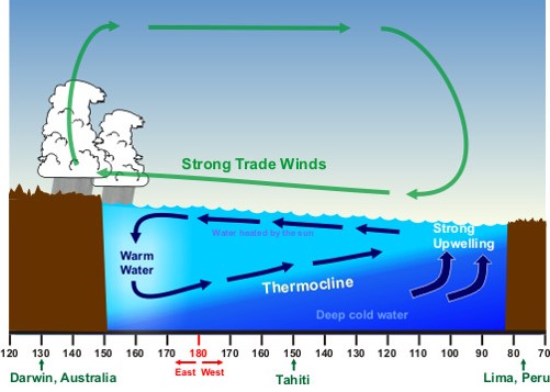
- NORMAL CONDITIONS: up-welling off the coast of Peru, warm water "piled up" in the Western Pacific
- El nino: surface current reversed, pushing warm water toward the Eastern Pacific Up-welling repressed which lead to warm water across Equatorial Pacific

- La nina: stronger trade winds than normal, causing a strong up-welling of cold water in the Eastern Pacific
SUNSPOTS
- they are caused by intense magnetic activity which inhibits convection and form area of reduced surface temperature
- gives us more harsh winters
- an eruptions can causes warming and cooling
- sunspots have effect on our climate
- Named after a Serbian mathematician, Milutin Milankovitch
- EXTREMELY long term effects that scientists think may be the cause of the ice ages.
- These are movements of the Earth that affect the amount of solar radiation that it gets.
- Precession: wobble of the axis 26,000 years full cycle
- Obliquity (nutation): the tilt angle of the Earth axis changes over time
- The greater the tilt the greater the differences in the seasons
- 40,000 year cycle
- Eccentricity: the shape of the earths orbit
